Bad Assumptions
El Niño begins in the Pacific. In New England, it shows up where the region thinks it is safe.

The water won’t ask permission before it enters the house. Through the bulkhead, up through the floor drain, under the garage door, across the low road that always floods but somehow still surprises everyone — by then, El Niño will sound less like a Pacific climate pattern than a pump running in the dark.
El Niño begins far from New England, in the tropical Pacific, where ocean heat rises toward the surface and changes the way the atmosphere moves. By the time anyone here feels it, the science will have become ordinary life: heat that doesn’t break, rain that doesn’t drain, winter that doesn’t hold, and coastal water arriving where people have learned to pretend it won’t.
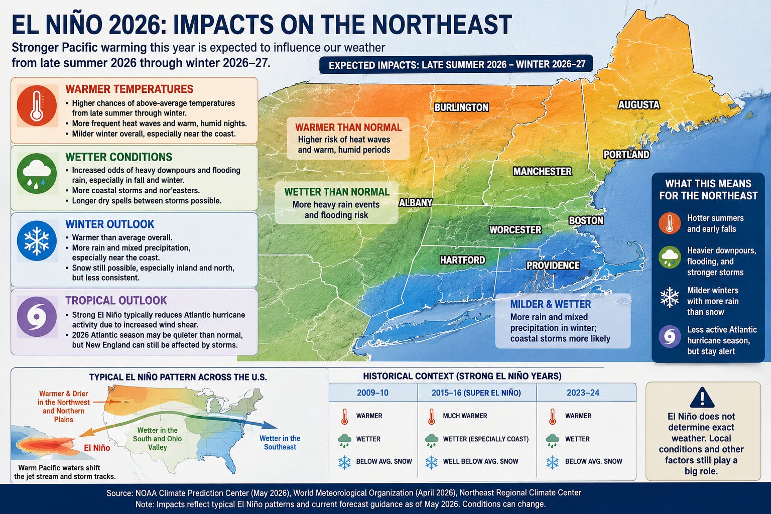
NOAA says El Niño is coming soon, with an 82 percent chance during May through July and a 96 percent chance that it lasts through the winter.¹ The Pacific hasn’t officially crossed the line yet, but the machinery is moving. Warm water is building beneath the tropical Pacific, and the models expect El Niño to develop soon. Its strength remains the open question.
That’s an awkward warning. It has no siren, no storm track, no red cone. It’s a forecast about conditions, and conditions are easy to ignore because they don’t yet look like damage.
New England doesn’t need a historic El Niño to have trouble. It only needs enough heat, moisture, and seasonal disorder to expose the places the region already knows are weak.
Every town has one: the road under the tracks, the stream behind the supermarket, the parking lot that becomes a pond, the basement with towels stacked near the bulkhead door. These are ordinary weak points. They’re also where climate risk first becomes visible.
Rain doesn’t always drain.
Vermont learned that again in July 2023, when days of heavy rain caused catastrophic flooding across parts of the state. Rivers reached record levels in some places, in some cases exceeding marks set by Tropical Storm Irene in 2011. Roads, bridges, homes, farms, and downtowns were damaged by too much rain falling over terrain and infrastructure that couldn’t move it away fast enough.²
A warmer atmosphere can hold more water vapor. The result can be dry stretches followed by sudden downpours. A town can worry about drought one week and pump cellars the next. That’s the new rhythm.
Heat doesn’t always let go.
People notice the afternoon high: the warning message on the phone, the shimmer over pavement, the road crew under hard sun. The more dangerous heat often comes after dark, when brick, asphalt, roofs, and parking lots keep giving warmth back and the night offers no relief.
That matters in older houses without central air, top-floor apartments, nursing homes, crowded bedrooms, and neighborhoods with fewer trees. Boston’s own climate planning has warned for years that heat isn’t distributed evenly; the burden falls hardest where pavement, housing, age, health, and income turn temperature into exposure.³ A person can survive a brutal day if the night gives relief. Without that relief, the body never gets its reset.
On the weather map, it’s a temperature anomaly. At the hospital, it’s a person.
Quiet doesn’t always mean safe.
El Niño often increases wind shear over the Atlantic, making it harder for tropical systems to organize. Colorado State University’s April forecast called for a somewhat below-normal 2026 Atlantic season: 13 named storms, 6 hurricanes, and 2 major hurricanes.⁴ Useful information. Not a promise.
New England learned that in 1991, when Hurricane Bob drove a 10-to-15-foot surge into Buzzards Bay. In Mattapoisett, 29 of 37 homes on Cove Road were destroyed; at Angelica Point, 32 of 35 homes were lost.⁵ Bob doesn’t have to come back for the lesson to matter. Averages don’t flood houses. Tracks do.
Winter doesn’t always stay winter.
A strong El Niño often favors milder conditions across the northern United States. In New England, winter doesn’t disappear so much as lose reliability. A warm winter can still be expensive. Snow turns to rain, rain turns to ice, thaw turns to freeze, a plowable storm becomes glaze, and a mountain builds a base only to watch rain take it away.
New England saw the cost of those margins in January 2018, when the so-called bomb cyclone combined heavy snow, wind, and coastal flooding. Boston set a new high-water mark of 15.16 feet, edging past the Blizzard of ’78 record. Streets filled with icy water. Coastal communities flooded.⁶ Two months later, another nor’easter produced the third-highest water level on record at the Boston tide gauge, with severe flooding from Portland, Maine, south to Cape Cod Bay.⁷
That’s the winter to worry about: the one that keeps changing its mind.
For a ski town, that means a season of negotiations. Snow, rain, freeze, thaw, ice, bare spots, and another warmup don’t only hurt the trail. They move into restaurants, rentals, gas stations, lift workers, plow drivers, and town budgets.
For a public works director, El Niño becomes salt piles, culverts, overtime, pump stations, road closures, and calls from residents. A forecast like this says where the system is weakest.
That’s the useful lesson. El Niño doesn’t create every weakness. It exposes the ones already there: undersized drainage, expensive shorelines, aging housing, winter economies dependent on snow, municipal budgets built around old seasonal patterns, and roads designed for a rainfall climate that’s changing faster than the infrastructure.
Modern forecasting doesn’t prevent damage. It buys time. The question is whether anyone uses that time to look at the weak places before the weather does.
Water remembers them. The low road. The blocked drain. The basement bulkhead. The culvert that was almost big enough. The seawall that worked until the tide rose higher.
El Niño won’t create those vulnerabilities. It’ll test them.
By then, the forecast won’t look like an index in the tropical Pacific. It may be a bedroom that won’t cool, a road closed under the railroad bridge, a December rainstorm eating the snowpack, or a nor’easter pushing water over the seawall.
The signal begins far away.
The consequences arrive at home.
And somewhere, after the forecast has been issued and before anyone’s ready to call it climate, the pump will start in the dark.
⸻
Bibliography
¹ National Oceanic and Atmospheric Administration, Climate Prediction Center. “ENSO Diagnostic Discussion.” Issued May 14, 2026.
² U.S. Geological Survey, “Flood of July 2023 in Vermont”; National Weather Service Burlington, “The Great Vermont Flood of 10–11 July 2023.”
³ City of Boston, Climate Ready Boston and related heat-resilience planning materials, discussing unequal heat exposure, urban heat islands, vulnerable populations, and neighborhood-level climate risk.
⁴ Philip J. Klotzbach et al. “Extended Range Forecast of Atlantic Seasonal Hurricane Activity and Landfall Strike Probability for 2026.” Colorado State University, April 9, 2026.
⁵ National Weather Service Boston/Norton, “Hurricane Bob.”
⁶ NOAA/NWS Boston, “On This Day in Weather History: January 4, 2018”; U.S. Geological Survey, “Blizzard of January 2018 in New England.”
⁷ U.S. Geological Survey, “Total Water Level Data From the January and March 2018 Nor’easters.”